Reservoir circular route "Talsperre Pöhl"


- 4:40 h
- 18.30 km
- 152 m
- 172 m
- 367 m
- 429 m
- 62 m
- Start: Parking lot dam Talsperre Pöhl
- Destination: Parking lot dam Talsperre Pöhl
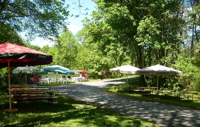
The hike, which is continuously signposted according to the yellow marking, leads over the gigantic dam past the tourist area of the Talsperre Pöhl boat landing, as well as the Gunzenberg campsite towards Voigtsgrün. Beautiful viewpoints and places to stop invite you to linger.
The Neuensalz and Thoßfell foredams are crossed. From Thoßfell to Gansgrün, the hiking trail runs along the road, otherwise mainly on field and forest paths, which is why it is not suitable for strollers or wheelchairs.
On your tour, learn about the history of the sunken village of Pöhl at numerous information boards, which had to give way to the waters of the reservoir in 1964, and enjoy the flora and fauna of the "Vogtland Sea."

Waypoints




Good to know
Pavements
- Unknown (22%)Street (18%)Asphalt (10%)Gravel (21%)Trail (21%)Path (8%)
Best to visit
- suitableDepends on weather
Directions
The recommended starting point is the parking lot at the dam. The continuously signposted hike leads over the gigantic dam past the tourist area of the Talsperre Pöhl boat landing, as well as the Gunzenberg campsite towards Voigtsgrün. Along the way, numerous viewpoints and various places to stop invite you to linger. Particularly popular is the romantic village of Altensalz with its cycling church, originally built in 1214. After the village, the Neuensalz and Thoßfell foredams are crossed. Up to this section, you are on paths that are easily passable by bike and also with strollers. From Thoßfell to Gansgrün, the hiking trail runs along the road, then again on field and forest paths, which require sure-footedness, are not stroller-friendly, and are only suitable for experienced mountain bikers. In the forest area between Rollhübel and Bosenhübel, about 60 steps must be overcome. Afterwards, the path runs through a woodland area, along fields, and through the village of Helmsgrün. It continues near the water to the first camping clubs in the northeastern area of the reservoir. From this point, the hiking trail leads through settled areas and runs through the tourist center of the reservoir in the last kilometer.
Route description:
Dam–boat landing, past the sunbathing lawn at the playground–barbecue area–camping site Gunzenberg–along the beach path to Voigtsgrüner Bay–permanent campsite Voigtsgrün–Altensalz–underpass of A72–over the Neuensalz and Thoßfell foredams to the northern shore of the reservoir–outskirts of Thoßfell–Thoßfell cemetery–underpass of A72–road to Gansgrün–Rollhübel–Göllischbach–rest area on the west slope of Bosenhübel–Helmsgrün–sailors’ campsite on the castle peninsula–road to the castle peninsula is crossed–Rodlera–Rodlera bungalow settlement–Neudörfel–Neudörfel caravan settlement–leisure garden–dam.
History:
Learn about the history of the sunken village of Pöhl on your tour at numerous information boards and enjoy the flora and fauna of the "Vogtland Sea."
Simply follow the good signage around the Talsperre Pöhl!
The hike not only leads along the reservoir Talsperre Pöhl – it also equally follows the boundaries of the village Pöhl, which had to give way to the waters of the reservoir in 1964. With the decision to build the dam at the entrance of the Trieb into its narrow valley, the fate of Pöhl was sealed – a village that could look back on a long history. Because about 500 meters before the location of the Talsperre Pöhl dam stood the village, which was first documented in 1288 and was probably founded by Slavs. In 1956, the inhabitants of Pöhl first learned about the planned construction of the dam wall in the Trieb valley. Due to the reservoir construction, one of the most beautiful, culturally valuable villages in Vogtland was to disappear. They therefore demanded that it be seriously reconsidered whether the original project, to build the reservoir above Pöhl, could be realized so that the village could be preserved. Unfortunately, the inhabitants could not prevail. In 1956, the decision to build the reservoir was made. Although the opinion of the residents differed, the construction of the dam in the Trieb valley and the resulting flooding of Pöhl were decided.
Immediately, 530 people and 221 households, including 10 businesses, were affected by the reservoir construction. The vacant buildings were offered at a low price for demolition to interested citizens from Pöhl. The foundations of about 70 properties of the old village still exist and emerge at extremely low water levels, as has occurred several times in recent years. On August 1, 1961, the political community of Pöhl was finally dissolved. Thus, July 31, 1961, is considered the last day in the history of Pöhl.
Tour information
Loop Road
Stop at an Inn
Equipment
Use weather-appropriate clothing and bring sufficient drinks with you
Directions & Parking facilities
- Getting thereYou reach Pöhl from the A72. Take the Plauen-East exit towards Plauen, then turn right at the traffic light towards Möschwitz.ParkingDirectly at the parking lot at the damPublic transportation
The starting point of the route is accessible via Jocketa with the Vogtlandbahn or by bus from Plauen. For information, visit www.vvvogtland.de or call 03744/19449.
Additional information
Passenger ship landing
Tel. 037439 45050
www.talsperre-poehl.deVogtland Tourism Association e.V.
Tel: +49 (0) 3744/18 88 60
E-Mail: info@vogtland-tourismus.de
Internet: www.vogtland-tourismus.de
Places to eat:
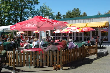
Snack bar "Schatzinsel" at the dam parking lot, 08543 Pöhl, Tel. 0172 4453258 (seasonal operation)
Bistro am Ankerplatz, Möschwitz-Hauptstr. 50, 08543 Pöhl, Tel. 0179 2438285 (seasonal operation)
Restaurant "Panorama", Möschwitz-Hauptstr. 44, 08543 Pöhl, Tel. 037439 440111, www.panorama-poehl.de (seasonal operation)
Inn "Auszeit" at the Gunzenberg campsite, Möschwitz-Hauptstr. 40, 08543 Pöhl, Tel. 0171 6142447 (seasonal operation)
Inn "Strandhaus Schlosshalbinsel", Helmsgrün-Schlosshalbinsel 32, 08543 Pöhl, Tel. 037439 6394, www.strandhaus-poehl.de (seasonal operation, 900 m from the path)
Kiosk "Zum Seeblick" & Helmsgrün - Schlosshalbinsel - 08543 Pöhl, Tel. 0171 1705731 (seasonal operation, 900 m from the path)
Yogi-Box, Helmsgrün-Schlosshalbinsel 32 B, 08543 Pöhl, Tel. 0162 2668084, www.erlebnisfloss-yogibox.de (seasonal operation, 900 m from the path)
Knüpfer's Restauration, Thoßfell-Hauptstr. 7, 08541 Neuensalz, Tel. 03741 416110, www.knuepfers-restauration.de (400 m from the path)
Strandcafé in the leisure and adventure garden, Jocketa – Am Freizeitgarten 1, 08543 Pöhl, Tel. 0172 3567424 (seasonal operation)
Restaurant "Talsperrenblick", Jocketa - Pöhler Str. 49, 08543 Pöhl, Tel. 037439 44959 www.talsperrenblick.de (100 m from the path)
Sights on the tour:
Dam of the Talsperre Pöhl, 08543 Pöhl
Julius-Mosen lookout tower (400 m from the path)
Passenger ship landing, Möschwitz – Hauptstr. 48, 08543 Pöhl, Tel. 03743945060, www.talsperre-poehl.de
Talsperre Pöhl climbing forest, Möschwitz-Hauptstr. 46, 08543 Pöhl, Tel. 0173 6855171, www.kletterwald.de
Church Altensalz, Dorfstraße 9, 08541 Altensalz, Tel. 03741 413268
Neuensalz and Thoßfell foredams
Leisure and adventure garden, Jocketa-Freizeitgarten 1, 08543 Pöhl
Information boards point out the history of the "Sunken Village Pöhl" and other special features of the Talsperre Pöhl and surroundings
Literature
Further information can be found on the pages of the Vogtland Tourism Association at www.vogtland-tourismus.de or by phone at 03744/188860 as well as at other tourist information centers along the route.
Author
Tourismus Marketing Gesellschaft Sachsen mbH
Bautzner Straße 45/4701099 DresdenOrganization
Vogtland - Sinfonie der Natur
License (master data)
Vogtland - Sinfonie der Natur

Author´s Tip / Recommendation of the author
- Combine the hike with a boat tour on the reservoir!
Safety guidelines
Moderate difficulty. Very good fitness required. Mostly well-passable paths. Sure-footedness required. Only partially suitable for cyclists.
Not barrier-free or stroller-friendly.
Map
- You can obtain maps, among others, at the Tourist Information of the Talsperre Pöhl at the Gunzenberg campsite
Download GPX file