Reservoir Trail Zeulenroda


- 11:15 h
- 41.44 km
- 395 m
- 395 m
- 289 m
- 401 m
- 112 m
- Start: Zeulenroda
- Destination: Zeulenroda
The Reservoir TrailⓇ was completed in 2009 and certified by the German Hiking Association as a “Quality Trail Wanderbares Deutschland.” The first section around the Zeulenroda reservoir received this title already in 2006. The path has 89% natural trail markings. Idyllic stream courses, forest areas, viewpoints, and the constant proximity to the water characterize the trail as a natural experience. The entire circular hiking trail is 45 km long. There are 6 connections on the Reservoir Trail that allow different circular hikes from 3 to 18 km.

Waypoints



Good to know
Best to visit
- suitableDepends on weather
Directions
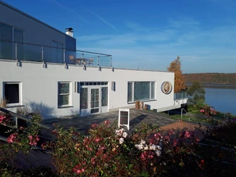
The path leads the hiker on well-passable trails all around Zeulenrodaer Meer. Therefore, entry is possible at different points. We start from the hiking parking lot at the Bio-Seehotel. Here we walk along the Seesternpanoramabühne towards the town. Use the many activity spots! Then it goes past the small arts open-air stage towards the beach bath. Next, you enter the hilly forest and walk along the water's edge towards the Riedelsmühle forebay. Continuing on the south side to the tip of the 6-kilometer-long reservoir to the Kesselsmühle. Now you walk directly along the water's edge back to the forebay dam. Over quite hilly terrain, which is also popular with mountain bikers, it goes on towards Stelzendorf. Past the village pond, also a forebay, along the bungalow village Zadelsdorf and the deep cuts of the "fjords" until shortly before Quingenberg. If you feel like a sailing trip, take the detour. Then it goes uphill to Silberfeld. Shortly before, we leave the turning road towards Sichelberg. We follow the path that now meanders through meadows, fields, and forests to the Weida/Pisselsmühle pre-dam. Here we walk along the water's edge over Piesigitz to the Wärterhof. It is bypassed via Bermichshof, and we walk back past the balancing basin Weidatalsperre. Through the forest along the Grobisch, we reach the shore of the Weidatalsperre again and follow it until the path turns through the forest towards Weisendorf. Shortly before the village, the path turns again towards the Teufelskanzel and leads in meandering loops back to the hiking parking lot at the Bio-Seehotel.
Tour information
Loop Road
Stop at an Inn
Equipment
For the almost 45-kilometer-long path, appropriate good hiking equipment should be used.
Directions & Parking facilities
- Getting thereYou can reach Zeulenroda via the A9 exit Triptis. Continue via the B2 to Auma, and via the L1087 to Zeulenroda. Follow the signs to Bio-Seehotel in Zeulenroda.ParkingThe hiking parking lot is available as a public parking lot.Public transportation
Hikers can arrive by train to Zeulenroda, onward travel by bus to the starting point is possible.
Further information is offered by the PRG at 03661/706565 or the Vogtland Tourism and Traffic Center at 03744/19449 or www.vogtlandauskunft.de
Additional information
Tourism Center Zeulenrodaer Meer
Bleichenweg 30 (directly at the Zeulenroda beach bath)
07937 Zeulenroda-TriebesPhone: 036628 987064
E-mail: tourismus@zeulenroda-triebes.de
Internet: www.zeulenrodaer-meer.deLiterature
Further information can be found on the Vogtland Tourism Association pages at www.vogtland-tourismus.de or at 03744/188860 as well as in the other tourist information centers along the route.
Author
Tourismus Marketing Gesellschaft Sachsen mbH
Bautzner Straße 45/4701099 DresdenOrganization
Vogtland - Sinfonie der Natur
License (master data)
Vogtland - Sinfonie der Natur

Author´s Tip / Recommendation of the author
Be sure to visit Patisserie Bergmann in Stelzendorf and enjoy one of the small delicacies or use the sunshine to take a pedal boat ride on the reservoir.
Safety guidelines
Pay attention to your fitness level and take appropriate amounts of drinks on the hike.
Map
Information material about the path and accommodations can be ordered free of charge at https://www.vogtland-tourismus.de/de/brochures.html.
Download GPX file