


- 6:20 h
- 22.58 km
- 377 m
- 377 m
- 269 m
- 472 m
- 203 m
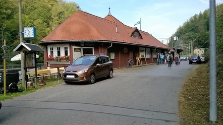
- Start: Klingenberg-Colmnitz station
- Destination: Klingenberg-Colmnitz station
Marking: white-green-white, white-red-white/also marked as a mining nature trail and ENSO trail



Pavements
- Unknown (1%)Street (8%)Asphalt (18%)Gravel (34%)Trail (26%)Path (13%)
Best to visit
- suitableDepends on weather
Directions
From Klingenberg-Colmnitz station, follow the green line over the Neuklingenberger Höhe to the dam. From here, follow the red line in the direction of Edle Krone (also marked as a mining nature trail and ENSO trail). Walk past the "Aurora Erbstolln" show mine to Dorfhain. At the entrance to the village on the right, cross the road bridge and walk up to Ochsenberg in the direction of Höckendorf. Before the village, turn left along the Heiligen Weg to the Huthaus and from here follow the path down to the Edle Krone museum station. If you don't want to take the train back, walk 7 km through the Seerenbach valley next to the historic Tharandt ramp to the lake. Tharandt ramp to the Seerenteich pond via the Lehmgrubenweg, A-wing and Fuchssteig in the Tharandt forest back to the start.
Recommended hiking map:
Topographic map GeoSN sheet 31 1:25 000
SK-Verlag Nr 04 Weißeritztäler und Tharandter Wald
Dr Barthel 121 Freiberg und Tharandter Wald 1:35000
Rolf Böhm Hiking map Tharandter Wald 1:20 000 (without dam)Tour information
Cultural Interesting
Loop Road
Stop at an Inn
Directions & Parking facilities
- ParkingKlingenberg-Colmnitz train station (free of charge)Public transportationTrain and bus
Bus stops: Klingenberg train station and Edle Krone
Additional information
Klingenberg municipal administration, Schulweg 1, 01774 Klingenberg
Tel.: +49 35055 68012, Fax: +49 35055 68099
karin.schmieder@gemeinde-klingenberg.de,www.gemeinde-klingenberg.de
FV Edle Krone e.V., Tel.: 01739079574, info@edlekrone.de,gufiguide@t-online.deDigital hiking pin
https://www.erzgebirge-tourismus.de/digitale-wandernadelAuthor
Michael Erler
Organization
Erlebnisheimat Erzgebirge
Author´s Tip / Recommendation of the author
Places of interest
- Changeable nature in every season between mountain and valley
- Klingenberg drinking water dam (listed building)
- "Aurora Erbstolln" show mine (Tel. +49 351 6502700, www.auroraerbstolln.de)
Digital hiking pin:The hike is part of the digital hiking pin "Für Bahnfreunde". Download the SummitLynx app, activate your cell phone GPS and log in at check-in points worth seeing. These will take you on a total of 10 tours into the world of viaducts, railroad stations and fascinating museums on the subject.
The special thing about our digital hiking pins is that you can create your own personal tour book with pictures, texts and locations.
Map
- Recommended hiking map: Topographic map GeoSN sheet 31 1:25 000 SK-Verlag No. 04 Weißeritz valleys and Tharandt Forest Dr Barthel 121 Freiberg and Tharandter Wald 1:35000 Rolf Böhm Hiking map Tharandter Wald 1:20 000 (without dam)